
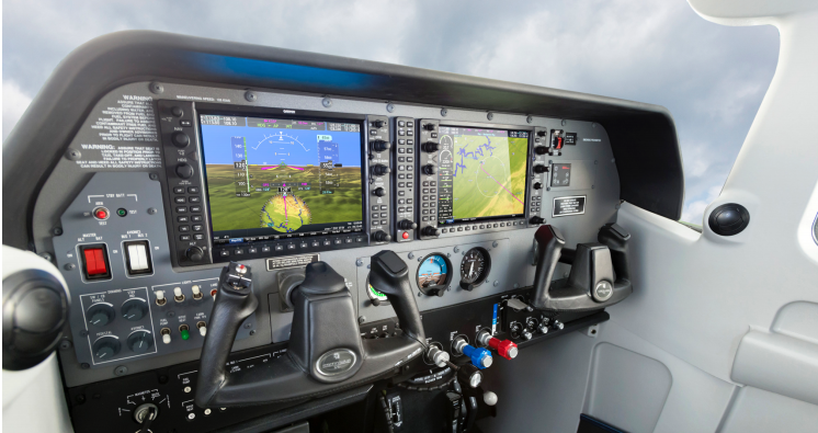
Garmin is pleased to announce the certification of the G1000® NXi integrated flight deck upgrade for the King Air C90. With the G1000 NXi, aircraft owners and operators receive a wealth of new features, innovative capabilities and added utility all within a modern flight deck. King Air C90 owners and operators can easily upgrade from the G1000 to the G1000 NXi with minimal aircraft downtime and installation labor to receive a next-generation integrated flight deck.
G1000 NXi on the Surface — Physical Enhancements and Display Advancements
The G1000 NXi system incorporates modern processing power that supports faster map rendering and smoother panning throughout the displays. Saving valuable time in the cockpit, the displays initialize within seconds after startup, providing immediate access to frequencies, flight plan data and more. The G1000 NXi system also incorporates contemporary animations, modernized design for improved readability and new LED backlighting, offering increased display brightness and clarity, reduced power consumption and improved dimming performance.
G1000 NXi for the Next Generation
Connext® wireless cockpit connectivity unlocks more capabilities from within the G1000 NXi integrated flight deck. Available as a standard feature with the G1000 NXi upgrade, Flight Stream 510 enables Database Concierge, the wireless transfer of aviation databases from the Garmin Pilot™ app on a mobile device to the G1000 NXi system. Flight Stream 510 also supports two-way flight plan transfer, the sharing of traffic, weather, GPS information, backup attitude information and more between G1000 NXi and compatible mobile devices running Garmin Pilot, FltPlan Go or ForeFlight Mobile. The D2™ Delta aviator watch can also sync with the Garmin Pilot app to ensure flight plan data matches throughout the cockpit.
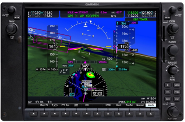 Geographical map overlay within the HSI is available on the primary flight display (PFD), which also supports the display of NEXRAD, FIS-B weather, weather radar, SafeTaxi® airport diagrams, traffic, terrain and more. For example, pilots can display SafeTaxi on the HSI map while preparing flight plan information on the multifunction display (MFD) or simultaneously display NEXRAD radar and traffic on the HSI map and view a variety of other SiriusXM® aviation weather products —such as lightning, storm cells and more — on the MFD.
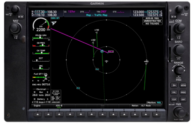 Optionally equipped to meet future airspace modernization initiatives, G1000 NXi equipped aircraft can be equipped to be rule-compliant with FAA Automatic Dependent Surveillance-Broadcast (ADS-B)requirements. G1000 NXi also supports the display of various ADS-B “In” benefits, including traffic and subscription-free weather with the installation of the optional GTX™ 345R1 transponder. Installation of GTX 345R also adds exclusive traffic features, such as Garmin patented TargetTrend™ and TerminalTraffic™ technologies, to further enhance the traffic picture. TargetTrend provides pilots with a more intuitive method of judging target trajectories and closure rates, while TerminalTraffic displays a comprehensive picture of ADS-B-equipped aircraft and ground vehicles throughout the airport environment. These ADS-B “In” benefits combine to give pilots superior situational awareness tools throughout the terminal and en route environments.
The G1000 NXi integrated flight deck also supports the following additional features:
- Comm frequency identification displays the station ID as well as frequency type.
- Display of sectional charts as well as IFR low/high en route charts on the MFD.
- NEXRAD weather radar imagery can be overlaid on the moving map and animated on the MFD as well as overlaid on the HSI map.
- Vertical Situation Display (VSD) incorporates terrain profile view on the MFD, taking into consideration the active flight plan, altitude constraints, and winds aloft.
- Preview departure and arrival procedures on the MFD prior to loading and activating the procedures.
- Optionally overlay European Visual Reporting Points (VRPs) on the moving map; VRPs are standard withing the navigation database.
- Three-color terrain shading incorporates green, yellow and red contouring, which depicts that the aircraft is 2,000 feet, 1,000 feet and 100 feet, Above Ground Level (AGL), repsectively.
- Aircraft maintenance personnel experience faster system software upgrades and streamlined equipment replacement.
- Two GDU Display's
- Flight Stream 510
- SurfaceWatch Feature Enablement
- Pilot's Guide
- Cockpit Reference Guide

