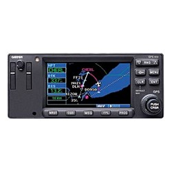
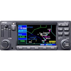
The GNS 530 represents the single biggest idea in integrated avionics in years. Traditionally, it would take a host of components to provide the capabilities represented in this one sophisticated box. It is a WAAS-upgradeable IFR GPS, Com, VOR, LOC and glide-slope with color moving map all rolled into one. A TSO'd VHF Com offers a choice of 25 kHz or 8.33 kHz spacing for 760- or 3040-channel configuration respectively. A huge Jeppesen database (that can be updated with a front-loading data card) contains all airports, VORs, NDBs, Intersections, FSS, Approach, DPs/STARs and SUA information. The GNS 530 makes practical use of this information with features like intelligent frequency nomination.
The brilliant colors of the GNS 530's 5-inch display make the pilot-critical information easy to read and interpret. Thanks to a high-contrast color display, the information can be easily read from wide viewing angles even in direct sunlight. It's especially true of the 530's basemap. Pilot's will enjoy enhanced situational awareness by seeing their position relative to cities, highways, railroads, rivers, lakes, and coastlines. But even more important, the appropriate use of color separates land data, terminal areas, route, and approach information for easy pilot scanning and reduced pilot workload. Simply put, the GNS 530 incorporates advanced procedure types usually found only in high-end FMS systems.
The GNS 530 has plenty of growth potential, as there are upgrade paths for WAAS compatibility, TAWS, and Terrain awareness. Pilots will enjoy the GNS 530 as an MFD, especially when it is coupled with traffic, lightning detection, and weather interfaces like Ryan TCAD, TIS from the Garmin GTX 330 Mode S transponder, or Goodrich SKYWATCH™, STORMSCOPE® WX 500. For the latest in graphical and textual weather information, the GNS 530 can connect to XM Satellite Radio's XM WX Weather Service via the GDL 69 datalink receiver. With the FDE prediction program, the GNS 530 may be used for oceanic or remote operations.
This mulitpurpose unit is available with either a 10-watt (GNS 530) or 16-watt (GNS 530A) COM.
The GNS 530's intuitive software and logical layout prove that this is a system built for pilots, by pilots. So much information. So easy to use. The GNS 530. It'll change the way you look at avionics.
- Panel mount with 12 channel GPS receiver
- TSO C151, Class B TAWS
- Color moving map with comm, VOR, LOC, GS, GPS and WAAS
- 760 channels (25 kHz spacing) or pilot selectable for 2280 channels (8.33 kHz spacing) 16 watt comm (GNS 530A)
- Autotune frequency selection from Jeppesen database
- Worldwide Terrain and U.S. obstacle database
- Worldwide basemap
- Size: 6.25 x 4.6 x 11 inches
- Unit Weight: 8.45 pounds installed (estimated)
- Width: 6.25"
- Height: 4.60"
- Depth: 11.00" behind panel, with connectors
- Unit weight: 8.5 pounds installed
- Display: Color LCD
- Power: 11–33 VDC
- Data Storage: Separate internal battery protects stored data for up to five years
- GNS 530A (16-watt COM)
- NavData Card
- Basemap: Worldwide Land
- GPS Antenna
- Installation Rack and Connectors


