
When installed as a CDI or HSI, the GI 275 is designed to accept a variety of GPS or navigation inputs, allowing up to two GPS sources and two VHF navigation sources. The GI 275 features an Omni Bearing Resolver that allows the flight instrument to interface to a variety of legacy navigators on the market without the need for an expensive adapter. With an optional magnetometer, it is also capable of providing magnetic-based HSI guidance. Vertical and lateral GPS, VOR/LOC and glide slope deviation can be viewed on the GI 275. CDI source selection can be accomplished through the touchscreen interface, while course and heading selection is completed using either the touchscreen or dual concentric knob. When pilots replace an older mechanical CDI or HSI, the GI 275 doubles as a modern digital indicator and adds MFD-like capabilities such as a moving map, weather, traffic and terrain.
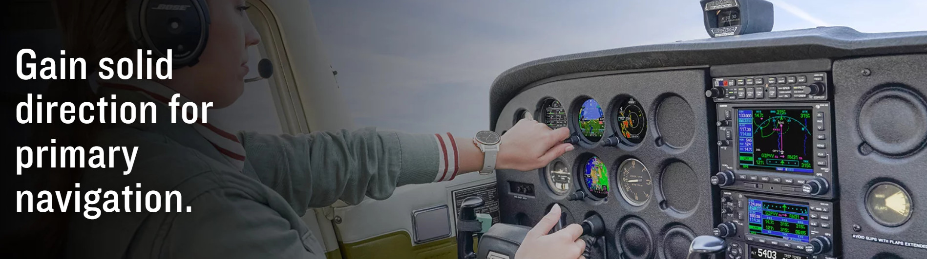
REPLACE ANALOG GAUGES WITH ELECTRONIC DISPLAYS
Adaptable to a full range of instrument formats and functions, our GI 275 electronic display lets you keep the classic look of your panel while upgrading with modern, reliable glass touchscreen display technology.

Out with the old, in with the new. It flush mounts in a standard 3-1/8” round cutout.

From piston singles to jets, it’s STC’d for over one thousand make/model aircraft.

How do you see it? Attitude, altitude, airspeed, CDI, HSI, MFD or EIS.

It’s available with precise digital ADAHRS and interface to drive select autopilots.

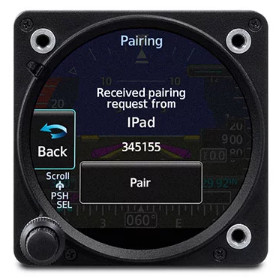
Connect your cockpit with built-in Wi-Fi® connectivity and BLUETOOTH® technology.

Know you’ll get home with up to 60 minutes of optional backup battery power

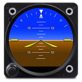
BASIC ATTITUDE
Save weight and maintenance expense: replace that aging vacuum pump-driven attitude indicator with a reliable solid-state ADAHRS-driven GI 275 electronic display.
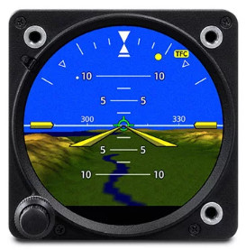
A LESS ARTIFICIAL HORIZON
To add situational awareness, your display can overlay attitude reference on an optional Garmin SVT™ synthetic vision landscape with flight path marker integration.
INSTRUMENT CONSOLIDATION
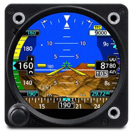
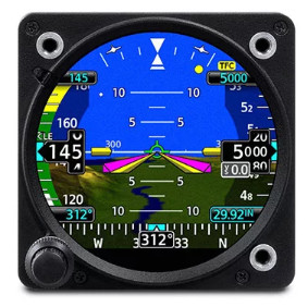
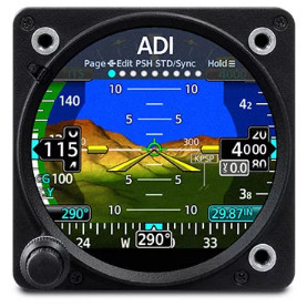
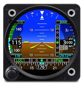
As your primary flight reference instrument, GI 275 features an integrated display to support all the essential readouts — attitude, altitude, airspeed and heading.
EDGE-TO-EDGE DISPLAY
The bright, high-resolution GI 275 touchscreen is sunlight-readable and maximizes the available space within the instrument panel cutout.
REFERENCE MARKERS
The GI 275 instrument can support display of selectable references to mark your arrival at a preselected altitude, heading or airspeed. Think overshoot avoidance.
ADI AUTOPILOT INTEGRATION
With optionally available built-in autopilot interface, GI 275 can provide precise attitude information to drive select autopilots and display flight director command bar cues.
STANDBY ADI
For select aircraft and glass cockpit systems, GI 275 can function as a standby flight instrument with MFD capability for mapping, traffic, weather and more.
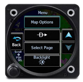
KNOB OR TOUCH CONTROLS
The touchscreen on GI 275 makes accessing its functions a breeze. A traditional concentric knob is also available for those who prefer that style of data input.
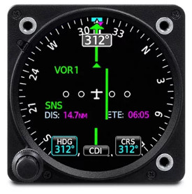
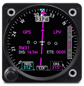
NAVIGATION GUIDANCE
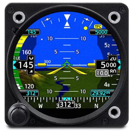
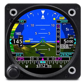
In addition to primary magnetic heading reference, GI 275 can accept inputs for VOR/LOC and/or GPS course guidance — along with distance and ground speed indications.
TRACK IN ALL DIMENSIONS
For climb/descent profiles and approaches, GI 275 can display both vertical and lateral GPS/VOR/LOC course deviation cues, when available.
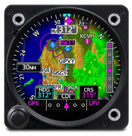
ENHANCED HSI
With appropriate nav inputs, GI 275 can optionally add HSI course guidance overlaid on a moving map display with flight plan legs, terrain, weather and more.
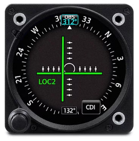
COMPLETE CDI SOLUTION
When paired with select VHF Nav radios or GPS navigators, GI 275 can serve as your primary indicator for making, adjusting and tracking course selections.
DUAL ADVANTAGES
With dual GI 275 displays as your primary flight instrumentation, reversionary backup capability retains attitude and heading data on the remaining HSI or MFD if an outage should occur.
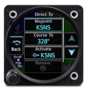
DIRECT-TO
For backup or nonprimary nav reference, built-in VFR GPS capability enables convenient Direct-to guidance with position depicted on the moving map display.

MULTIFUNCTION DISPLAY
When configured as an MFD, GI 275 can serve multiple roles, supporting displays for moving map, traffic, lightning, weather, terrain, radar altimeter, CDI and more.
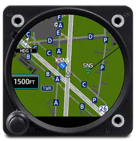
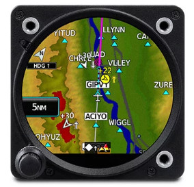
MOVING MAP
Within the MFD configuration, a dynamic moving map page offers views of terrain features, airports, airspace boundaries, navaids, flight plan routings and more.
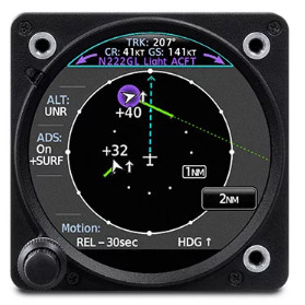
TRAFFIC AND WEATHER
With select ADS-B “In” datalinks, GI 275 MFD pages will support subscription-free U.S. weather and traffic displays, including TargetTrend™ and TerminalTraffic™ technologies.
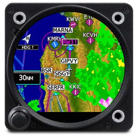
ANIMATED NEXRAD
When paired with an optional GDL® 69 SiriusXM® receiver, the MFD-configured GI 275 offers display capability for satellite weather coverage with graphical NEXRAD imagery.
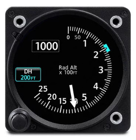
RADAR ALTIMETER
For applications that require precise tracking of aircraft altitude above the terrain, GI 275 can provide display capability for select radar altimeters, including the Garmin GRA™ altimeter series.
WIRELESS DATA STREAMING
Use built-in wireless connectivity to share data between the GI 275 and compatible mobile apps. Import databases. Stream weather, traffic, attitude information, EIS and more4.
Multifunction Display
Depending on the configuration and installation, the GI 275 is capable of displaying additional page functions and features beyond a traditional flight instrument. These features can include:
- A multifunction display (MFD) with a moving map can display terrain, obstacles, traffic, weather, airspace information, airways, and more.
- When interfaced to a GTX™ 345 or GNX™ 375, traffic information can be displayed on the dedicated traffic page or moving map. Patented TargetTrend™ relative motion technology and pop-up traffic alerts further enhance situational awareness.
- The GI 275 can also be interfaced to a variety of traffic systems, including select Traffic Advisory (TAS) and Traffic Alert and Collision Avoidance Systems (TCAS). Traffic advisories are displayed on the dedicated traffic page and moving map.
- SafeTaxi airport diagrams display runways, taxiways, Fixed Based Operators (FBO’s), hangars and more relative to the aircraft’s location on the airport surface.
- Terrain shading incorporates yellow and red contouring depicting the aircraft is 1,000 and 100 feet above ground level (AGL) respectively. Terrain information, as well as obstacle and WireAware™ database information can be viewed on the terrain and map pages.
- The GI 275 uses its internal terrain and obstacle database to provide audible and visual terrain proximity alerts, including, “terrain ahead, pull up” and “obstacle ahead, pull up.”
- When paired with the GDL 69 datalink receiver, the GI 275 is capable of displaying SiriusXM Aviation Weather. It can also display Flight Information Service-Broadcast (FIS-B) weather from either a GTX 345 or GNX 375.
- An airport information page displays a variety of information, including frequencies, runway dimensions and more.
- The GI 275 can be paired with the GRA 55/5500 and other third-party products to display a radar altimeter on a dedicated page. Visual and aural annunciations are also available.
- The GI 275 is compatible with the GFC 600 autopilot, as well as an array of third-party autopilots and can replace the primary attitude indicator installed with these autopilots. GFC 500 compatibility is expected later this year.
Built-in Wi-Fi enables Database Concierge, the wireless transfer of aviation databases to the GI 275. Pilots also have the option of transferring databases to the GI 275 using a USB flash drive and the GSB 15 USB charger. Databases can also be synced among multiple GI 275 flight instruments in a single cockpit. When configured to display engine information, the GI 275 can wirelessly send engine data to display within the Garmin Pilot app on Apple mobile devices. This data is also automatically synced and can also be viewed on the flyGarmin website. Wireless flight plan transfer via Bluetooth is available when the GI 275 is paired with a GPS 175, GNC 355 or GNX 375. Additional wireless functions include the sharing of GPS position and back-up attitude information with Garmin Pilot.
- Width: 3.25" (82.6 mm)
- Height: 3.25" (82.6 mm)
- Depth: 6.44" (163.6 mm)
- Depth with Connector: 7.40" (188.0 mm)
- Unit Weight: 1.9 lbs (0.86 kg) to 2.4 lbs (1.1 kg)
- Active Display Size: 2.69” diameter
- Display Resolution: 480 x 433 pixels
- Operating Voltage: 14/28 VDC
- Operating Temperature Range: -20°C to +55°C
- Altitude Range: -1,500 ft to 55,000 ft
- Wi-Fi Class: 802.11b/g/n
- GI 275 ADAHRS (or GI 275 ADAHRS + AP)
- GI 275 Connector kit
- GI 275 Battery pack
- GMU 11 Magnetometer (or GMU 44B for Class III aircraft)


")