
Garmin Introduces New GTN Software Update
 Garmin is pleased to announce several new enhancements and the addition of new features within the GTN 650/750 series touchscreen navigators. With new software (version 6.62) and a compatible ADS-B “In” receiver, pilots can now view new FIS-B weather products on the GTN. Also, when the GTN 650/750 is paired with a G3X Touch™ flight display in experimental/amateur-built aircraft, pilots now have the option to edit VFR flight plan information from the G3X Touch. These features and more are now available with GTN software version 6.62.
 New FIS-B Weather Product Support
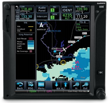
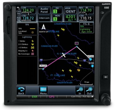
When paired with a compatible ADS-B “In” product such as GTX 345™ or GDL® 88, pilots can now access the latest FIS-B weather products (where available) on the moving map alongside flight plan information and dedicated weather pages within GTN 650/750. These new weather products include lightning, cloud tops, turbulence, icing (forecast potential), graphical AIRMETs (G-AIRMET) and center weather advisories (CWA). This adds to the growing number of Garmin products that already support these new weather products, including Garmin Pilot™ on Apple® mobile devices, G3X Touch and the aera 660® aviation portable.
G3X Touch™ Flight Plan Editing
Pilots who have a GTN 650/750 installed alongside a G3X Touch flight display in an experimental/amateur-built aircraft now have additional flight planning and editing options. VFR flight plans can now be completed on the G3X Touch display, and then automatically synced to the GTN navigator for added convenience when using either the G3X Touch or GTN.
 Additional Features
- The GTN 650/750 now display a selected altitude intercept arc on the moving map when they are installed with a compatible Garmin primary flight display (PFD) such as the G500 TXi/G600 TXi, G500/G600 or G3X Touch. When pilots input a preselected altitude on the PFD, the selected altitude arc will populate on the map page to indicate where the aircraft will arrive at that particular altitude.
- For customers with SiriusXM® Aviation Weather, pilots now have the option to alternate between base reflectivity and composite reflectivity NEXRAD weather radar imagery.
- Pilots operating into airports throughout the world that are not served by SBAS, can now receive advisory vertical guidance (LNAV+V) while flying LNAV approaches with the GTN 650/750.
- When datalink weather radar coverage is not available on the GTN 650/750, the area of “no coverage” is now transparent so pilots can still view airports, basemap information and more.
4 years ago