
Zaon Announces the MX1090 ADS-B Traffic Device
MX1090 For FlightClick here to view different versionsAs the airspace becomes ever more saturated with fast, high performance aircraft, Zaon is proud to introduce a solution which enables pilots to take advantage of new technology dedicated to enhanced early detection, while maintaining the safety and high detection rate of proven PCAS technology. ADS-B (Automatic Dependent Surveillance – Broadcast) is an automatic broadcast of position, altitude, and flight path information based on the GPS system. The concept enables an aircraft equipped with ADS-B “out” to broadcast their location, altitude, speed, and other important data than can then be used to help increase traffic awareness. Another feature of ADS-B includes the ability for ground facilities to uplink their RADAR data of all surrounding aircraft. This includes all aircraft detected within a 200NM range to the ground RADAR facility used. While all types of aircraft use ADS-B, today aircraft are manufactured with ADS-B “out” transponders (such as the GTX330), which means an ever increasing population of aircraft which can be detected. Many of these also tend to be high performance aircraft, which makes early detection paramount to a safe flight. While ADS-B is a new technology, there is an increasing number of aircraft which are broadcasting ADS-B data intended to be utilized for traffic awareness. The MX1090™ monitors the 1090ES ADS-B link, as well as TIS-B messages as it provides highly accurate traffic information peer-to-peer, which means the MX1090 works in any country, and throughout the world. Military aircraft can also be shown, with an early warning to reflect both their speed and flight path if a converging course is determined. Although TIS-B and ADS-B provide more detailed traffic information, transponders will continue to be used indefinitely, which enables PCAS XRX™ to be a very powerful detection tool for non ADS-B aircraft. To ensure traffic is detected, all three technologies are combined, completing the “traffic triangle.” When flying in areas where TIS-B is not available, the MX1090 can still provide ADS-B and correlation traffic from your XRX. |
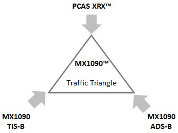 When you fly in an area of TIS-B coverage, the local ground RADAR facility will broadcast real-time traffic data, which means that any aircraft flying within range of this facility can be received by the MX1090. However; Any aircraft too low to be sensed will still be detected by your XRX. Because the XRX detects the transponder directly, the closer you are the better the XRX can detect them. This is opposite of TIS-B, but it is why you can refer to the “traffic triangle” as a complete hybrid system. When you fly in an area of TIS-B coverage, the local ground RADAR facility will broadcast real-time traffic data, which means that any aircraft flying within range of this facility can be received by the MX1090. However; Any aircraft too low to be sensed will still be detected by your XRX. Because the XRX detects the transponder directly, the closer you are the better the XRX can detect them. This is opposite of TIS-B, but it is why you can refer to the “traffic triangle” as a complete hybrid system.While the MX1090 can function as a stand-alone ADS-B traffic detection system, it is highly recommended that it be used in conjunction with the XRX to ensure the detection of non ADS-B aircraft. No portable ADS-B system can detect all aircraft, which is why the MX1090 is designed to manage multiple sources of traffic. The MX1090 offers an easy solution to adding ADS-B traffic to your Garmin GPSmap, or favorite portable GPS system. |
X2 PCAS XRX COMPATIBILITY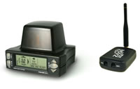 While the transponder will remain to be the consistent element of collision avoidance, all Zaon ADS-B products will include compatibility with the PCAS XRX, including the MX1090. The MX1090 can be connected to the XRX by either Bluetooth or a short power/data connector. Whether you choose a standard cable or bluetooth, the MX1090 collects traffic data from the XRX, correlating ADS-B, TIS-B, and XRX traffic into a single output. While the transponder will remain to be the consistent element of collision avoidance, all Zaon ADS-B products will include compatibility with the PCAS XRX, including the MX1090. The MX1090 can be connected to the XRX by either Bluetooth or a short power/data connector. Whether you choose a standard cable or bluetooth, the MX1090 collects traffic data from the XRX, correlating ADS-B, TIS-B, and XRX traffic into a single output.As ADS-B requires GPS, the MX1090 contains an internal WAAS capable GPS receiver. This enables the MX1090 to continually and accurately position intruding aircraft in relation to your current position, whether you fly in North America, Europe, South America, or South Africa or anywhere in the world. The MX1090 is limitless when it comes to region. |
ADD ADS-B TRAFFIC TO YOUR GARMINThe MX1090 has three (3) configurations to choose from depending on your needs. These options include Bluetooth, Wi-Fi, or non-wireless. With Bluetooth, the MX1090 can communicate with either the XRX or to our integration partners. To view traffic on your Garmin display, the MX1090 has several options. Zaon can also construct any custom solution for the Garmin series including:
GPSmap® and aera® are trademarks of Garmin Ltd. |
Zaon can also customize any solution for your Garmin GPSmap, including custom bluetooth options. |
|
 Click here for larger view Click here for larger view |
TCAS accuracy for PCAS prices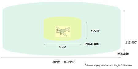 Of all the benefits to adding ADS-B traffic, the increase in range is most evident. A head-on scenario can often reach closure speeds in excess of 600 KTS. When detected from a range of 30 NM or more, this provides at least 3 minutes advanced notice. When detected from a range of 50 NM, the closure time increases to 5 minutes. The altitude window for detection is extended to ±12,000 to ensure rapid descending/ascending aircraft are detected with advanced warning. For example; an aircraft climbing at 6000 FPM will only take 2 minutes to reach your altitude with a 12,000 foot separation. The MX1090 and the XRX have complete opposite advantages and limitations. When combined, this effect increases the total traffic capabilities beyond even the most sophisticated TCAS systems when distant range, azimuth, and speed data are compared to price. |
| XRX Advantages & Limitations | X2 Hybrid Maximum Detection | MX1090 Advantages & Limitations |
| Maximum Range for passive is 7NM | Total Range 0 to 100 NM | Range from 30NM up to 100NM |
| Azimuth ±22.5° Range accuracy ±20% | Accuracy ±0.1° / 0.1 NM | Azimuth and Range accuracy ±0.1° / 0.1 NM |
| Limited to one display output | Display Traffic Multiple Displays | Multiple display capability |
| Detects any transponder equipped aircraft | Detect Both ADS-B and non ADS-B | Detects only ADS-B equipped aircraft |
| Maximum Altitude FL220 | Effective Altitude -1000 - FL510 | Maximum Altitude FL510 |
| Collision path warning to 2NM | Head On Collision Warning 30NM | High Speed Collision path warning to 30 NM |
Technical Specifications
| MAXIMUM ALTITUDE: | FL500 (pressurized mode) |
| MAXIMUM ALTITUDE: | FL320 (non-pressurized mode) |
| MAXIMUM SPEED: | 1000 KTS (GS) |
| TEMPERATURE: | -25C (-13F) to +75C (+167 F) |
| Formats: | DF-17, DF-18, DF-19, TIS-B (DF-19, Mode-S, Mode A/C) 1 |
| Garmin Displays: | 396 and up |
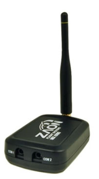
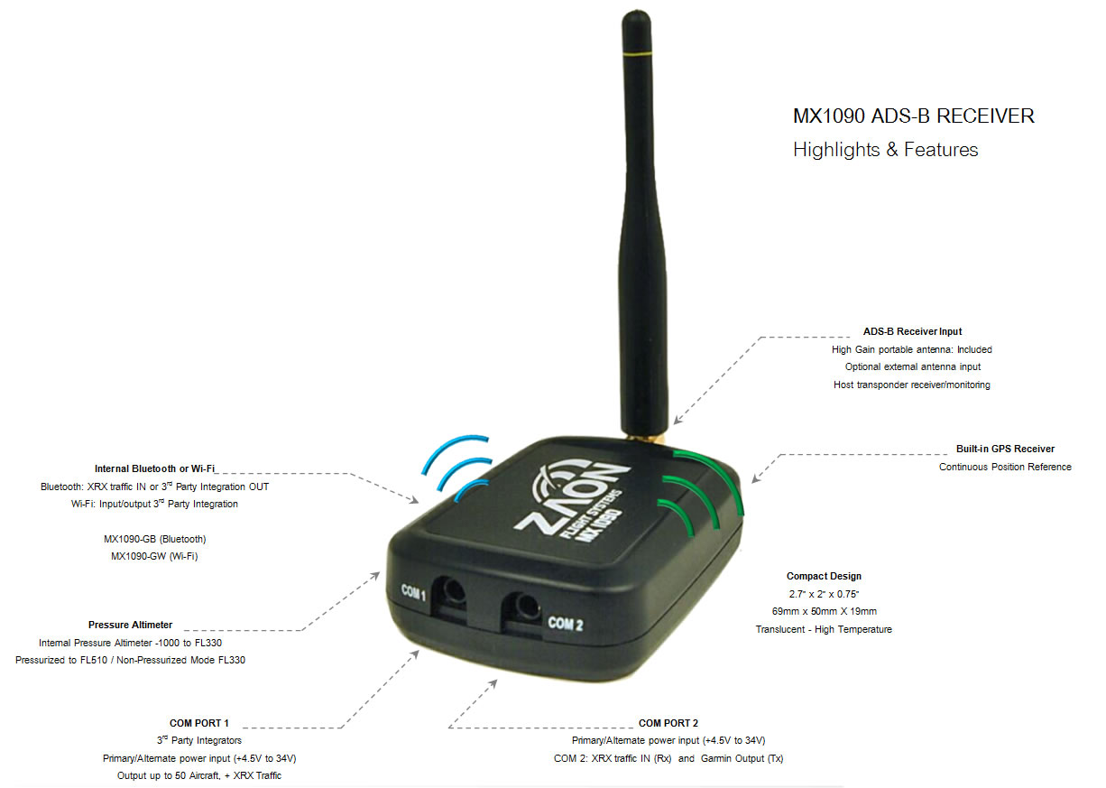
| COM 1 Port: | Integration RS232 Data I/O |
| COM 2 Port: | RS232 Garmin Output Format (Tx) / XRX Traffic Input (Rx) |
| Maximum RF input: | +10 dBm |
| Total Dynamic Range: | 100 dB |
| DC power input: | +4.7V to +34V (COM PORT 1 or 2) |
| DC current: | 100 mA |
| DME EMI suppression: | 70 dB |
| HOST Transponder detection: | -32 to +10 dBm |
| GPS Sensitivity (tracking): | -164 dBm 2 |
| Pressure Altimeter: | -1000' to FL330 |
| Altitude Window: | ± 12,000 feet (Garmin display) |
| Target Capacity: | 50 (+3 XRX targets, 8 targets total on Garmin systems) |
| Display Range: | 31 NM (Garmin display) |
| Track Range: | Up to 100 NM |
| Range resolution: | 0.1NM |
| Azimuth resolution: | 0.1° |
| ADS-B position resolution: | ½ LSB (.00005 degrees latitude or longitude) |
| Data position output formats: | Latitude / Longitude / Range (NM) / Bearing (degrees relative true north) Latitude DD.dddd / Longitude DDD.dddd |
| Wireless Options: | Bluetooth or Wi-Fi3 |
| 1 Other formats are available and can be customized. (DF-19 restrictions apply) | |
| 2 Internal GPS antenna must have a clear view of the sky | |
| 3 With optional internal Wi-Fi or Bluetooth (Can be upgraded post-purchase) | |
13 years ago