
Garmin Unveils the aera 796 and 795 Portable Touchscreen Aviation Navigators with 3D Vision
 |
OLATHE, Kan./September 14, 2011/Business Wire — Garmin International Inc., a unit of Garmin Ltd. (NASDAQ: GRMN), the global leader in satellite navigation, announced today the aera 796 and aera 795, a new series of portable aviation navigation devices. As Garmin’s new flagship portable aviation product, the aera 796 incorporates the popular features of the GPSMAP® 696, while also adding new capabilities such as a touchscreen user interface, pilot-selectable screen orientation and 3D Vision. The aera 796 also takes the pilot one step closer to a paperless cockpit with a digital document viewer, scratch pad and pre-loaded geo-referenced AeroNav IFR and VFR enroute charts. “Pilots continue to embrace touchscreen in the cockpit because they see how much faster and easier it is to access information while in flight,” said Gary Kelley, Garmin’s vice president of marketing. “Not only does the aera 796 have the increasingly popular touchscreen user interface, but it is so robust with features and capabilities that only a dedicated aviation device can offer. With everything from 3D Vision to electronic charts and weather data, it’s almost like having a glass cockpit that you can fit in your flight bag.” |
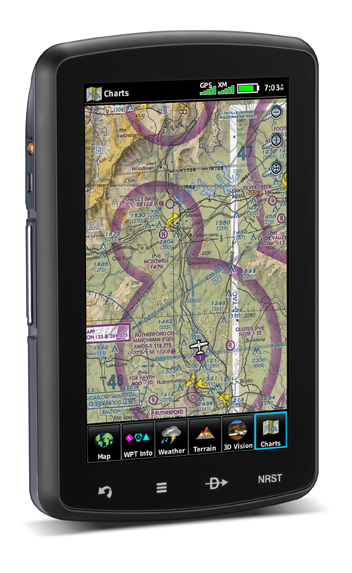
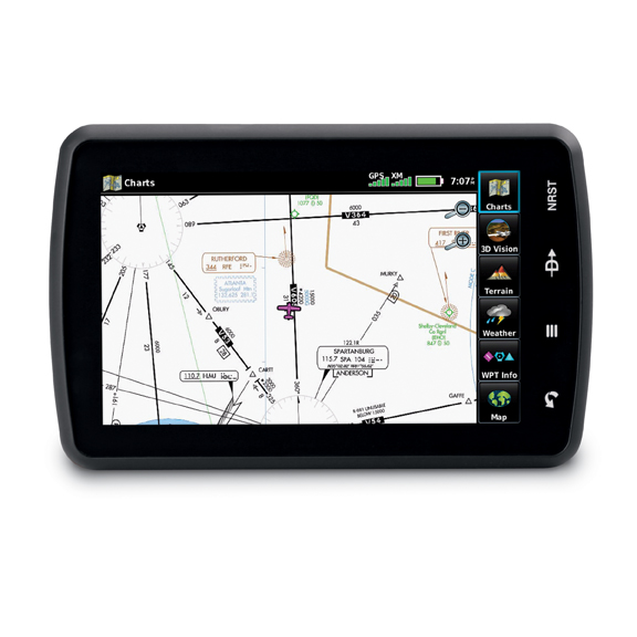
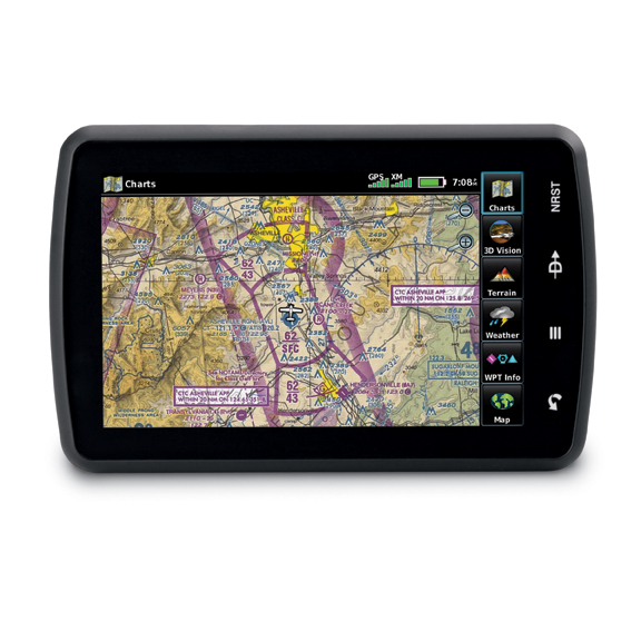
The aera 796 has a high-resolution, 7-inch capacitive touchscreen display that can be viewed in portrait or landscape mode. The physical design has been optimized to fit on the yoke and is sized perfectly as a knee-mounted device. There are four touch keys on the bezel of the unit representing “Back”, “Menu”, “Direct-To” and “Nearest” for quick navigation to frequently used functions, and because the aera 796 is customizable, the user can also pick favorite features or pages to anchor as icons along the bottom of the screen for even faster access. The display has large, finger-touchable icons with intuitive pictures and labels to indicate their function such as: map, terrain, 3D Vision, WPT info, FPL list, active FPL, numbers, doc viewer, charts, weather, SiriusXM and tools. Pilots can choose any of these functions by simply touching the appropriate icon. The touchscreen interface also allows the pilot to quickly pan across the map and pinch zoom. |
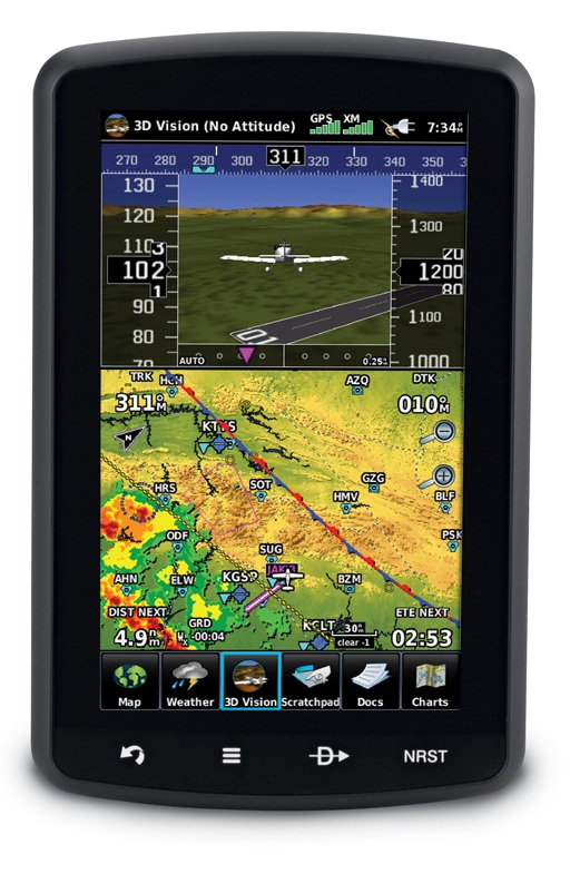
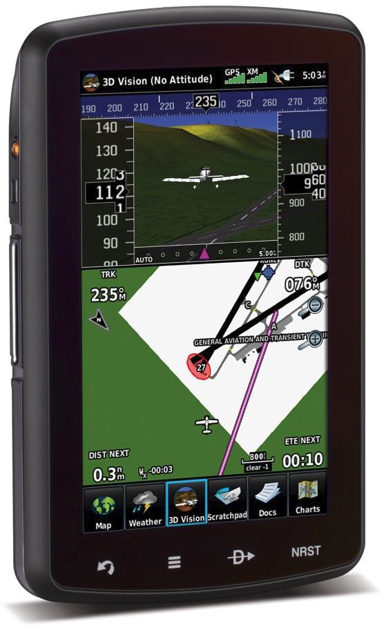
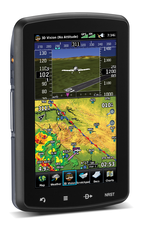
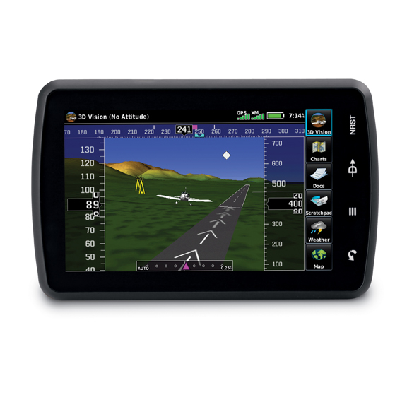
Enhanced situational awareness with 3D VisionThe aera 796 features 3D Vision, a unique 3D view of database-generated terrain. 3D Vision uses GPS position and the terrain-alerting database to recreate a behind-the-aircraft perspective view of the topographic landscape. The resulting virtual reality display offers pilots a supplemental 3D depiction of land and water features including terrain, obstacles, runways and airport signposts all shown in relative proximity to the aircraft. With the flick of a finger, the 3D view can be rotated around the aircraft to easily view the surrounding terrain. Using forward-looking terrain avoidance capability, the aera 796 predicts in advance where potential hazards may exist and colorizes the landscape showing amber or red overlays on those areas. Any towers or obstacles that may encroach upon the flight path are color-highlighted and clearly displayed with height-appropriate symbology. |
 |
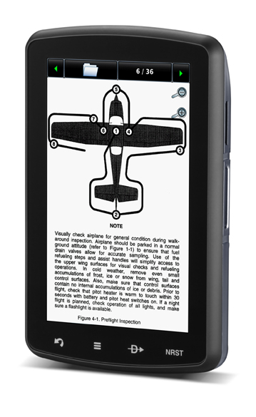 |
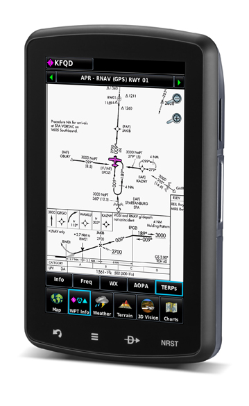
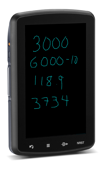
The path to a paperless cockpitBecause of the comprehensive offering of electronic charts, the aera 796 may be qualified for use as either a Class I or Class II Electronic Flight Bag (EFB). Geo-referenced IFR Enroute charts and VFR Sectional charts come pre-loaded, and the aera 796 also includes geo-referenced Garmin FliteCharts®, an electronic version of the AeroNav U.S. Terminal Procedures Publication. With FliteCharts, pilots can quickly find and view all departure procedures (DP), standard terminal arrival routes (STARs), approach charts and airport diagrams. For pilots who prefer Jeppesen charts and diagrams, Garmin also offers a ChartView enablement option. Garmin ChartView utilizes Jeppesen’s extensive library to provide global charting capabilities.Other new features include a built-in digital document viewer that enables the pilot to load and view PDF documents, JPEG photos, and many other electronically formatted materials including checklists and detailed performance/procedural data from the aircraft flight manual. There is also a convenient scratch pad for writing down clearances or other important notes. |
The addition of optional City Navigator data on the aera 796 allows the user to search and locate any desired surface address for use as a flight plan waypoint or for direct-to navigation. This makes it even easier for helicopter and fixed-wing operators to respond to critical missions around streets and highways, survey land or perform search and rescue operations. |
Garmin’s patented Panel Page on the aera 796 offers a backup solution to the instrument panel with its exclusive display of GPS-derived panel information, including track indication, GPS altitude, groundspeed, vertical speed and turn indication. Plus, the internal GPS provides position updates five times per second (5 Hz), allowing it to present flight data more smoothly and accurately. |
 |
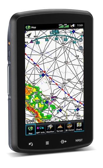
Like many other Garmin portable devices, the aera 796 also includes a GXM™ 40 receiver for XM WX Satellite Weather and SiriusXM Radio. XM WX Satellite Weather gives next generation radar (NEXRAD), aviation routine weather reports (METARs), terminal aerodrome forecasts (TAFs), temporary flight restrictions (TFRs), lightning, winds aloft, turbulence forecasts, PIREPs, icing forecast and several other important weather products. The weather data may be laid directly over the unit’s navigation and topographic map databases. And because the GXM 40 is powered through the aera 796, the set up is simple, and satellite weather and radio can continue to operate for up to four hours without external power. XM WX subscription data and coverage area information is available from XM WX Satellite Weather. The aera 796 will also display traffic if coupled to a compatible traffic source like the GTX 330, showing TIS (traffic information service) where available. Garmin has increased the interface capability through the addition of a second serial port to allow even more connectivity simultaneously. With two serial ports, the pilot can display traffic information, send frequencies to a Garmin SL30 or SL40 radio, send position information and more to other select aircraft devices. |
| Taxiing at unfamiliar airports is made easier thanks to SafeTaxi®, which includes geo-referenced diagrams of over 1,000 U.S. airports that identify runways, taxiways and hangars, as well as the aircraft’s exact location on the field. The aera 796 also has AOPA Airport Directory data, an electronic version of AOPA’s popular U.S. pilot guide, which includes information for over 5,300 public-use airports and nearly 7,000 FBOs. Optionally, pilots can purchase the AC-U-KWIK airport directory database, which features worldwide airport information for more than 7,800 airports globally, and contains hard-to-find information for pre-flight planning in North America, Europe, Asia, Central America, the Caribbean, South America, Africa and Australia. North American customers that do not require XM WX Satellite Weather and SiriusXM Radio, may be interested in the aera 795 Americas that has identical features to the aera 796 except that it is not XM capable. Garmin also offers aera 795 Atlantic and aera 795 Pacific versions for customers in Europe and in Asia/Australia, respectively. The aera 795 Atlantic and Pacific are pre-loaded with VFR reporting points (VRPs), AC-U-KWIK international airport directory data and obstacles where available. |
 |
| Part No. | Model | Price |
| 010-00967-10 | aera 796 Portable Touchscreen Aviation Navigator with 3D Vision | $2,499.00 |
| 010-00967-00 | aera 795 (Americas) Portable Touchscreen Aviation Navigator | $2,199.00 |
| 010-00967-02 | aera 795 (Atlantic) Portable Touchscreen Aviation Navigator | $2,199.00 |
| 010-00967-02 | aera 795 (Pacific) Portable Touchscreen Aviation Navigator | $2,199.00 |
 |
 |
 |
 |
 |
 |
13 years ago