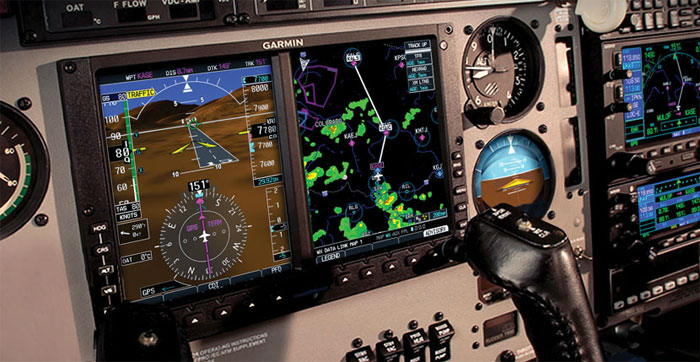
Using technology derived from Garmin’s highly successful G1000™ integrated avionics system, the new G600 and G500 suites bring a wealth of graphical flight capabilities to your cockpit retrofit. The Garmin G500 is a lower-cost alternative, designed specifically for most Class 1/Class 2 aircraft (singles or twins under 6,000 lbs). The G600, which comes with scaled version of Garmin’s SVT as standard, is also approved for Class 1 and 2 aircraft – as well as for larger Class 3 piston and turbine aircraft between 6,000 lbs. and 12,500 lbs MTOW.
An Easy Next Step
The "glass cockpit" revolution is fully underway. And now, with the introduction of Garmin’s new G600 and G500 systems, most of the advantages and features of this revolutionary glass technology are available for easy aftermarket retrofit or OEM factory installation in a wide variety of aircraft. Think 3-D perspective SVT™ Synthetic Vision scaled for the display. Think autopilot/flight director interface. Think digital AHRS attitude/heading reference. Using technology derived from Garmin’s highly successful G1000™ integrated avionics system, the new G600/G500 package brings a wealth of graphical flight capabilities to the retrofit market. Combine your choice of these attractively priced twin-screen units with your existing Garmin avionics stack, and – voila! – you’re looking at a state-of-the-art digital command center that fits neatly into the 10-inch wide space vacated by the standard "six-pack" instrument cluster in your panel.
| HOW THE UNITS COMPARE: | G500 | G600 |
|---|---|---|
| Approved for Class 1 Aircraft (typically piston singles under 6,000 lbs.) | Yes | Yes |
| Approved for Class 2 Aircraft (typically piston twins and turbine aircraft under 6,000 lbs.) | Yes | Yes |
| Approved for Class 3 Aircraft (typically piston or turbine aircraft between 6,000 lbs. and 12,500 lbs) | No | Yes |
| Software design assurance level | Level C | Level B |
| Garmin SVT Synthetic Vision Technology | Optional | Standard |
| GWX 68 Radar interface (radar LRU sold separately) | Optional | Standard |
| Internal TAWS-B terrain alerting | No | Optional |
| GAD 43 replaces select A/P gyro attitude with AHRS references and provides bootstrap heading, yaw information, and baro corrections | Optional | Standard |
Consolidating all primary flight, navigation and sensor data in a “big picture” suite of multi-tasking color LCDs, the G600/G500 systems’ identical 10-inch wide bezels fit neatly into the panel space vacated by your standard six-pack of mechanical 3-inch flight instruments. In many cases, the existing airspeed indicator, artificial horizon and altimeter can be relocated to serve as standby instruments, adjacent to the G600/G500 flight display. Also, optional Garmin trim rings are available for the installation, enabling the existing instrument panel to be modified and re-used – thus affording a significant cost savings over an all-new panel. FAA Approved data for replacing most panels is also included with the G600/G500. Dual LCD screens mounted side-by-side in a single bezel put Primary Flight Display (PFD) and Multi-Function Display (MFD) capabilities right in front of the pilot – bringing a whole new level of capability and situational awareness to the avionics retrofit market.With standard FliteCharts® or optional ChartView™, electronic approach plates can be displayed on the MFD.
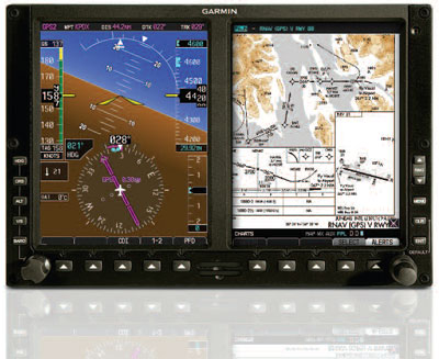
Within the display bezel itself, the large VGA-quality (640 x 480 pixel) screens offer brilliant color and crisp readability, even in direct sunlight, thanks to Garmin’s advanced RGB backlight design. The new SVT-capable PFD screen on the left shows attitude, airspeed, climb rate, altitude and course/heading information – while the right side MFD provides detailed moving-map graphics of the aircraft’s current position in relation to ground features, chart data, navaids, flight plan routings, and more.
At last, there’s a way to bring the “glass cockpit” capabilities you’ve been wanting onboard the aircraft you already have:With Garmin’s G600 or G500 retrofit flight display systems. Combine your choice of these affordable one-bezel units with your existing Garmin avionics stack, and – voila! – your old six-pack instrument layout is transformed into a state-of-the-art digital command center with AHRS attitude/heading reference and dual 6.5-inch LCD displays.
Garmin flight displays with SVT ™ capability bring a new perspective to cockpit retrofit .
For faster scanning, both the Primary Flight Display (PFD) and Multifunction Display (MFD) are paired directly in your field of view. On the PFD, your attitude display is over 50% larger than those of traditional 3-inch flight instruments. And for added situational awareness, a scaled version of Garmin SVT™ Synthetic Vision Technology is now available (standard on the G600, optional on the G500) to create a 3-D “virtual reality” perspective view of flight and enroute terrain features. It’s a major advance in pilot workload reduction, safety and situational awareness. And it’s Garmin’s first certified retrofit package to make SVT available. So, if you love the idea of flying a digital glass cockpit – but hate to think of parting with your current aircraft – this is clearly the upgrade option you’ve been waiting for.
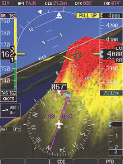
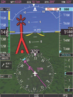
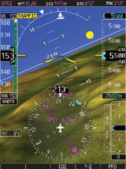
Terrain alerting with Garmin SVT is a real attention-getter. It’s standard on G600; optional on G500. Potential terrain conflict areas are indicated by a color overlay on the topography: Yellow for caution. Red for WARNING.
When visibility is low, it’s reassuring to have Garmin’s Towers and Obstacles database looking out for non-terrain structural hazards. Color-coded 3-D symbols are depicted with SVT to indicate relative proximity of vertical obstruction.
Using familiar TCAS/TAS/TIS symbology in a 3-D format, optional Garmin SVT makes it easier to spot moving traffic. You can see if they’re above or below your altitude. And as intruders get closer, the symbols get larger.
Garmin SVT™ adds a new dimension.
The available SVT synthetic vision feature uses sophisticated graphics modeling to create a virtual topographic landscape from the G600/G500’s terrain-alerting database. This enables the PFD to display a clear 3-D depiction of ground and water features, airports, obstacles and traffic – all shown in relative proximity to your aircraft. Instead of a flat blue-over-brown flight display, you’ll see an in-depth perspective view of realistic terrain features rising into the sky. So, rather than looking at the PFD, you’ll have a sense of looking through it – to “see” what lies beyond the nose of the aircraft. Fact is, the Garmin SVT presentation looks so real, it’s almost like having a clear-day out-the-window view of your flight situation – even in solid IFR, nighttime VFR, or other low visibility conditions.
The AHRS advantage.
You can see that a lot of forward thinking went into the design of the new G600/G500 glass cockpit displays. But we didn’t stop there. At every level of technology and system architecture, Garmin engineering has yielded gamechanging advances in reliability, innovation and performance. In place of less reliable gyro instruments, the system uses Garmin’s proven GRS 77 Attitude and Heading Reference System (AHRS). The GRS 77 is the same AHRS installed in thousands of G1000-equipped aircraft, with accumulated flight hours in the millions. Using additional comparative inputs from GPS, magnetometer and air data computer, the Garmin AHRS achieves unprecedented levels of spatial-sensing precision and dependability. What’s more, unlike some competitive attitude/heading sensors, it’s even able to restart and fully realign itself while the aircraft is moving. The G600/G500 can function as a selection hub for available navigation sensors on the aircraft. The unit will provide course deviation, vertical deviation, heading bug, course pointer and ARINC 429 GPS roll-steering information to select autopilots, as appropriate. In addition, if the autopilot does not support ARINC 429 roll steering, the G600/G500 can act like a roll steering converter via the heading input. Flight director display is supported for select autopilots. And with the GAD 43 adapter unit (standard on G600; optional on G500), an enhanced autopilot interface is available – allowing AHRS to drive your autopilot in place of a gyro-mechanical ADI (such as the familiar KI-256). The GAD 43 can emulate the many existing gyro interfaces, using far more reliable AHRS data to provide the required attitude, heading, yaw input, baro correction, and alerting information to the autopilot. This typically enables the system’s costly ADI and/or other remote gyros to be replaced with a far more affordable (and space-saving) attitude indicator as one’s backup instrumentation. To further simplify the system interface for retrofit, the aircraft’s existing fuel gauges and engine monitoring displays are retained – along with such other panel displays as marker beacons, altitude alerts and DME indicator, if installed. Navigation inputs are provided byWAAS-enabled versions of Garmin’s popular GNS 430W/530W or 480 systems (sold separately), with VOR/Localizer/Glideslope inputs also usable from the Slimline SL30 TSO’d nav/comm transceiver.
Databases, datalinks, data-everything.
By referencing built-in terrain and mapping databases, the Garmin G600/G500 MFD provides a clear, concise picture of where you are and where you’re heading. At a glance the Garmin basemap helps identify cities, roads, rivers, lakes, and other ground features along your flight path. Added safety is provided by a built-in terrain elevation database that uses color coding to alert you as you approach rising terrain. (Class B TAWS alerting is also available as an option with the G600 only.) On the ground, built-in Garmin SafeTaxi™ airport diagrams help pilots navigate over 900 U.S. airports with confidence – as their aircraft’s exact location is graphically highlighted on the field. Garmin FliteCharts®, which feature electronic versions of NACO terminal procedures charts for U.S. airports, come standard with the system1. As an alternative, pilots can select optional ChartView™ instrument approach plates and airport surface charts for the G600/G500 (Jeppesen JeppView™ for MFD subscription required). ChartView is unique in its ability to overlay a geo-referenced aircraft symbol on the electronic approach chart, providing a visual crosscheck of your progress inbound. Then, when you land, ChartView will automatically display the destination airport’s surface diagram.
Front-loading SD card slots on the G600/G500 bezel make updating of charts and software a simple plug-in procedure.What’s more, for data access beyond the cockpit itself, it’s easy to combine the G600/G500 with a variety of optional sensors and data links. For example, to help keep an eye on other planes in your vicinity, you can access Traffic Information Service (TIS) alerts on your G600/G500, simply by adding a GTX 330 Mode S transponder. Or, you can select from available TAS and TCAS I systems such as Garmin’s GTS 800/820/850 series. Want digital on-board weather radar capability? Just add the versatile Garmin GWX 68. (Interface enabling card is required for G500; standard interface included for the G600). Also, you can opt for Garmin’s GDL 69/69A™ data link receiver, which provides graphical U.S. weather alerting via XM Satellite Radio.(XM subscription required.)With this option, graphical depictions of NEXRAD weather, METARs, TAFs, TFRs, winds aloft, echo tops, surface precipitation, lightning strikes, storm cell data, and more, can be received and displayed anywhere in the U.S., regardless of altitude. You can pan and zoom in on weather anywhere in the country. Or even extend the NEXRAD screen range out to 2,000 nm for nationwide monitoring of current weather.What’s more, for the best in enroute entertainment, there’s also a user interface offering over 170 channels of XM digital audio programming, when installed with the GDL 69A receiver.
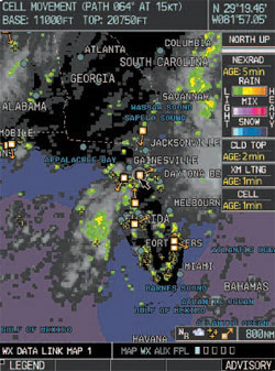
Weather datalink capability, via XM™ WX Satellite Weather service, can provide color NEXRAD, METARs, TAFs, lightning, and other U.S. data displays.
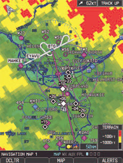
With its built-in elevation database, the G600/G500 system provides an extra margin of safety in recognizing terrain/obstacle conflict situations. Available terrain alerts are supported with optional TAWS-B (G600 only).
| FEATURES AT A GLANCE |
|---|
| Dual 6.5-inch diagonal color LCD displays; portrait orientation |
| Large and clear display fonts |
| 4.8-inch diagonal attitude indicator |
| Large and clear display fonts |
| SVT synthetic vision renders terrain-alerting data into realistic virtual landscape - optional on G500 |
| Proven solid-state Attitude and Heading Reference System (AHRS) and Air Data Computer (ADC) |
| XM WX Satellite Weather and XM Radio (optional) |
| Built-in terrain elevation and towers/obstacles databases |
| Standard FliteCharts® and SafeTaxi® databases |
| Optional ChartView™ shows the aircraft position on the Jeppesen approach charts and airport surface diagrams |
| Offers control/display for available GWX 68 airborne weather radar |
| Displays GPS mapping, as well as optional traffic, terrain and datalink systems |
| Flight director for selected autopilots |
| Optional TAWS-B alerting (G600 only) |
| Real-time winds aloft data on PFD |
| GAD 43 adapter provides AHRS reference for autopilot interface on select models (allows replacement of gyro attitude, yaw, and baro correction; radar stabilization; and bootstrap heading) – optional on G500. |
It all makes sense.
With Supplemental Type Certification provided under an Approved Model List (AML)2, standardized retrofit installation of the G600/G500 in your aircraft is simple and straightforward. The unit neatly fits into the “six-pack” slot in your instrument panel – and connects through your plane’s existing electrical system. So, you could be flying behind that great-looking Garmin glass even sooner than you expected. Better still, you’ll be flying with the confidence and peace-of-mind that comes with our award-winning Garmin Product Support. To find out more about the futuristic flight capabilities available now with a G600/G500 retrofit, give us a call today.
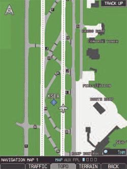
Helpful Garmin SafeTaxi™ airport diagrams identify runways, taxiways and hangars, as well as your aircraft location on field.
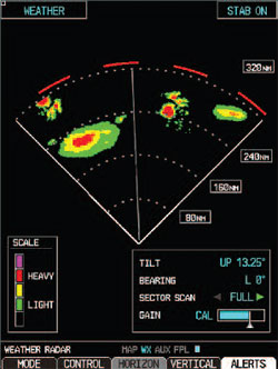
With 6,500 watts of magnetron muscle, Garmin’s GWX 68 digital radar (sold separately) can provide an extra measure of onboard weather protection. The radar interface is included with the G600 system; an optional enabling card is available for the G500.
2 Ask us for current AML list

