Please note the information below is for the legacy G3X system. For information on Garmin's new G3X Touch, click here.


Live the Suite Life

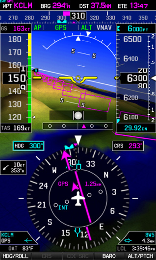
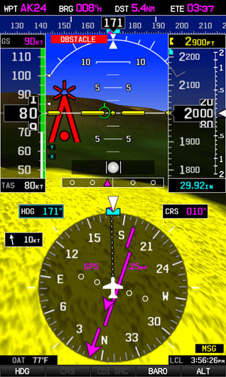
All the capabilities you want in a true “glass cockpit” are brought together in the G3X flight display system. Designed specifically for experimental/kitplane and light sport panels, this scalable system lets you grow as your needs and budget allow. This easy-to-install suite can contain up to three redundant PFD/MFD configurable displays, all of which contain a built-in GPS and big, bright sunlight readable 7" high-resolution WVGA screen. The G3X provides full primary flight display (PFD) attitude/directional guidance along with electronic engine gauges, terrain/obstacles alerting, geo-referenced FliteCharts® and SafeTaxi® airport diagrams. Optional SiriusXM® weather, ADS-B “In” with traffic and weather, ADS-B “Out” transponder, and angle of attack sensor can all be added easily. An affordable Garmin autopilot system is also available with advanced features like coupled approaches and auto-trim, as well as flight director, indicated air speed hold and straight and level button when installed with an optional control panel. You can choose a single- or multi-display configuration with separate PFD and MFD displays — or you can even add a third co-pilot’s display, if desired.

One System. Many Solutions.

The integration and versatility provided by the G3X electronic flight displays makes it easy to customize the ideal panel layout for your aircraft. You can start with a single display — or use as many as three displays — to fit the space, avionics stack, and budget available. Shown here are just a few examples of what’s possible and practical in a G3X installation.

Single Display

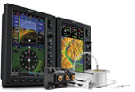
The versatile G3X panel-mount glass displays work like building blocks, allowing you to grow your system to fit your needs and budget. You can start with a single display that combines full primary flight (PFD) attitude/directional guidance with electronic engine monitoring and moving-map multifunction (MFD) capabilities.

Dual Display

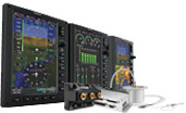
Want a two-screen flight deck layout with separate PFD and MFD displays? That’s an easy upgrade with G3X. You get a large-format attitude and heading display, paired with your moving map and engine gauge data. A built-in Garmin network interface allows for full reversionary capability on either screen.

Triple Display

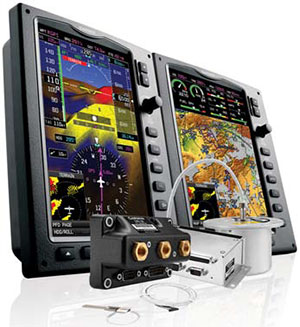
For the ultimate in non-certified glass cockpit suites, this configuration adds a third display for the co-pilot’s position. The Garmin network interface allows for a maximum of three displays to be interlinked in your panel. You can use it as an optional second MFD to display even more data at once — like dedicated engine information and moving map.

Hardware

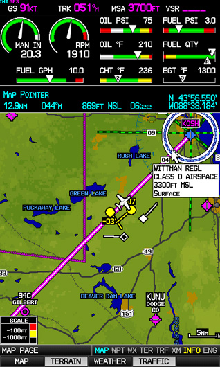
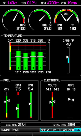
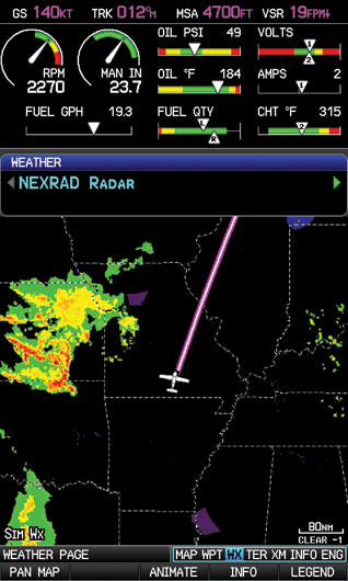
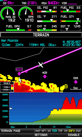
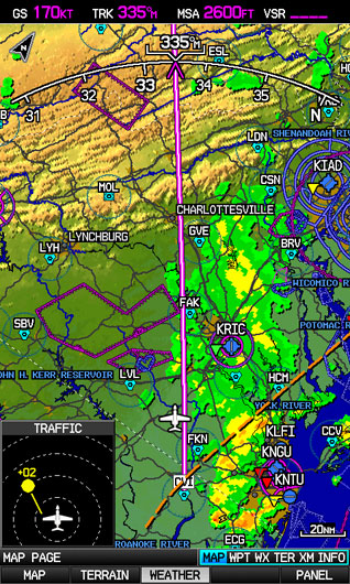
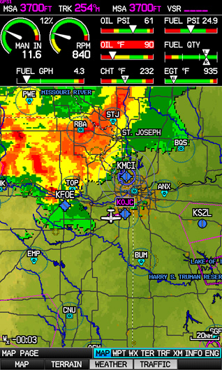
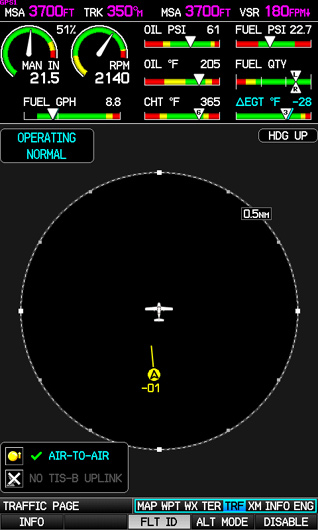
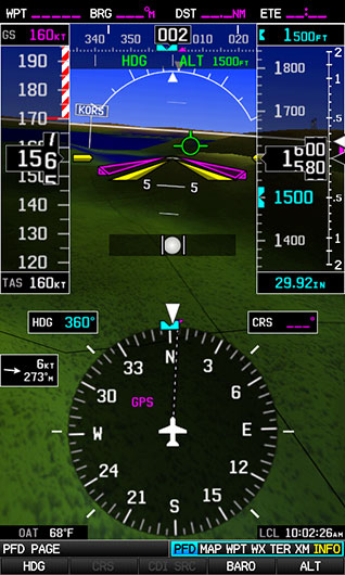
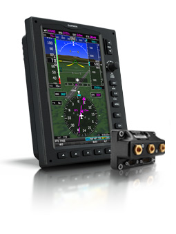
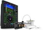
Combine Simplicity with Sophistication The multi-tasking Garmin displays that comprise your G3X suite are scaled to fit the panels (and price ranges) of most experimental/kitbuilt and light sport aircraft. Each display features a big 7" high-resolution WVGA screen, built-in high-sensitivity WAAS GPS receiver, rotary joystick cursor control for data entry, redundant power inputs, and soft keys for mode selection. There’s a front-loading SD™ card slot for easy updating of software and databases. Plus, a built-in aviation basemap helps provide realistic visual reference — identifying cities, roads, rivers, lakes and other guide points. You can choose topographic VFR or airway-style IFR map modes. And there’s also a built-in terrain elevation database that uses color-coding to alert you as you approach potentially hazardous terrain. Both overhead and vertical profile views of this data are graphically depicted on the terrain page. The backbone of the G3X Touch system is the same tried-and-true sensor technology as the G3X. In fact, you can upgrade from the G3X to the G3X Touch with just a few alterations to your existing panel and wiring. Each easy-to-read display features a 10.6" high-resolution WVGA screen with infrared touchscreen technology with a large touchpint that that ensures precise inputs and minimizes inadvertent touches – even with gloves. LED indicators make it easy to tell when sensors have been correctly connected and flexible mounting options allow the GSU 25 ADAHRS to be mounted either on back of the display or remotely. A front-loading SD™ card slot makes it easy to update software and databases. The aviation basemap helps provide realistic visual reference — identifying cities, roads, rivers, lakes and other guide points. You can choose topographic VFR or airway-style IFR map modes. And there’s also a built-in terrain elevation database that uses color-coding to alert you as you approach potentially hazardous terrain. Both overhead and vertical profile views of this information is graphically depicted on the terrain page.

Each G3X System comes with the following:
  • 1 or more displays (with or without XM/SiriusXM weather capability)
  • Air Data, Attitude and Heading Reference System (ADAHRS)
  • Magnetometer, which determines the aircraft’s magnetic heading
  • Outside air temperature probe
  • Engine Indication System (EIS) interface (engine sensor kits sold separately)

Integrated Autopilot

Add an Affordable AFCS

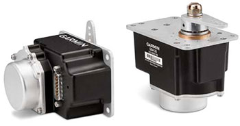
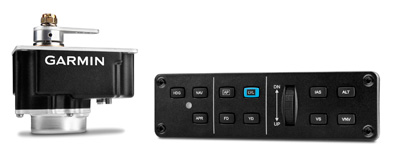
All it takes is the addition of Garmin’s affordable GSA 28 “smart” servo units to give your G3X a range of autopilot capabilities similar to those provided by the high-end GFC™700 systems found on thousands of certified aircraft. You have the option of purchasing 1 servo (roll only), or 2 servos (pitch + roll) to add the level of capability you want. Even better, the Garmin system includes automatic trim functionality at no additional cost. And for added redundancy, it’s the only integrated autopilot in its class to offer standalone operation in the event of EFIS display outage or shutdown. The optional GMC 305 control panel is a dedicated interface unit that provides advanced autopilot modes like indicated airspeed hold, independent flight director, and third axis yaw damper (when installed with appropriate servos). A control wheel integrated into the GMC 305 makes for easier pitch, vertical speed and airspeed adjustments. Plus, for added safety, the panel’s advanced LVL mode button commands automatic recovery from steep or unusual attitudes — enabling the autopilot to return your aircraft to straight-and-level flight. Installation of the system is simple and straightforward, with industry-standard servo mounting kits available — as well as airframe-specific versions for the popular Van’s RV series (RV-4/6/7/8/9/10 models).

Autopilot Options for G3X

Single-axis Configured with 1 GSA 28 integrated servo for roll only autopilot Dual-axis Configured with 2 GSA 28 integrated servo units for pitch and roll autopilot Optional GMC 305 Control Panel A separate autopilot control panel for dedicated mode selection, as well as access to additional autopilot modes including Indicated Airspeed Hold (IAS), Level Recovery (LVL), and Yaw Damper (YD).


Features

See the Big Picture

Attitude Awareness In place of sensitive mechanical gyro instruments, the G3X system uses the latest in GPS-aided ADAHRS (Air Data, Attitude Heading and Reference System). Based on solid-state technology derived from Garmin’s popular certified G1000 system, the GSU-25 ADAHRS provides accurate and reliable referencing of aircraft attitude, heading, rate, vector and acceleration data. For additional redundancy, the G3X system optionally supports multiple ADHARS.

Rich, Interactive Map and more The G3X contains a powerful, rich and detailed moving map display. If you’ve ever wondered at any given time how far away upcoming airspace, inclement weather, traffic or anything on the moving map was, G3X makes it a cinch! Simply press the knob and scroll anywhere on the map and using your current position, the G3X displays the distance, bearing, and time to that location on the map as well as the elevation and GPS coordinates of that location. Other powerful features include an “Always On” bearing pointer to the nearest airport, extended runway centerlines, easy creation of user way points, altitude alerting tones when leaving the indicated bugged altitude, display of pilot defined checklists, and flight and engine data logging of up to a 1,000 hours on a single 2 GB SD card.

Engine Instruments Configurable EIS displays of engine, fuel and systems data can be accessed and monitored on the G3X via the system’s ADAHRS remote sensor unit. Engine Sensor Kits are available for popular models of Lycoming, Continental, Rotax and Jabiru engines.


Synthetic Vision With Garmin SVX™ synthetic vision technology for the G3X, you’ll always know what lies ahead — even in solid IFR or nighttime VFR conditions. Using sophisticated graphics modeling, SVX provides a 3-D “virtual reality” perspective for enhanced situational awareness. Synthetic Vision displays terrain using different shades of color and even includes streams, lakes and large bodies of water. Even more it displays obstacles, traffic (optional), the airport environment that includes airport sign posts and the runway. For additional awareness, your route is outlined with “windows” on the PFD screen. This virtual “highway in the sky” varies in size to depict the flight path in perspective, making it easy to visualize enroute legs, course intercepts, final approach courses, runway thresholds and more.

SiriusXM Weather & Radio Optional XM™ WX Satellite Weather is supported by the G3X with optional subscription. When partnered the Garmin datalink receiver built into the GDU 375, the system can display graphical NEXRAD radar, METARS, TAFS, TFRs, winds aloft, lightning strikes, storm cells and more. What’s more, over 170 channels of XM audio can also be enjoyed through the interface.

SafeTaxi Diagrams When your aircraft touches down, built in Garmin SafeTaxi airport diagrams are there to help you navigate over 1,000 U.S. airports with confidence. You’ll see a depiction of your aircraft’s exact location overlaid onto taxiways, runways, hot spots, hangars and other airport facilities.


Terrain and Obstacles In addition to the worldwide Garmin land basemap that helps identify cities, roads and bodies of water along your flight path, the G3X also provides a built-in database of both terrain elevation and obstacles that overlay on the main moving map page. And the dedicated terrain page helps to depict terrain and obstacles of concern based on the aircraft’s current altitude. The terrain page can be displayed using a 2D map, profile view or both (pictured). While not directly focusing on the display, both visual and audible alerts help provide an automated warning to the pilot. Even more, the G3X provides a 500’ callout for additional confirmation while on approach for landing at the destination airport.

FliteCharts Terminal Procedures The G3X system comes preloaded with geo-referenced Garmin FliteCharts, which displays your position on AeroNav–format terminal procedures including IFR approach plates for thousands of U.S. airports. Optional geo-referenced ChartView is also available for those who prefer Jeppesen-style charts (subscription required).


Traffic Advisories To help you keep nearby air traffic under surveillance, the G3X supports traffic with either a TIS (Traffic Information Service) via an interface with your Garmin GTX 23 ES Mode S transponder or a GTS 800 active traffic system. Traffic displays in 3D on the PFD’s synthetic vision (SVX) with directional arrow indications to help point out traffic at a glance. Traffic also displays in 2D right on the MFD’s moving map page or a separate dedicated traffic page can be configured. And visual and audible alerts of nearby traffic help keep your eyes outside of the aircraft.

Reversionary Mode If your installation includes a separate PFD and MFD, you’ll have additional reversionary backup should a failure of either display occur. In reversionary mode, the remaining GDU combines critical flight instrumentation with engine readouts and navigation information in a single–screen consolidated presentation.

Advanced Avionics Integration The G3X is natively integrated with Garmin navigators including the popular new GTN series, GNS and SL30 avionics. This brings advanced integration including display of the flight plan from the GTN/GNS navigators as well as more detailed leg instructions such as holds and procedure turns. In addition to advanced integration with Garmin’s navigators, the G3X will command compatible autopilots so you can fly like the pros. The G3X provides pitch and roll steering commands to the autopilot. And all this information is displayed and easily controlled using the softkeys and knobs on the PFD. It will even fly a preset Vertical navigation (VNAV) profile, that makes getting down to the desired altitude and distance from the airport, like the traffic pattern, a cinch. Even better, when combined with a GTN or GNS navigator, this tight integration provides near-GFC-700-like capability allowing pilots to couple the autopilot to fly the entire approach down to minimums.

ADS-B Weather Gain access to subscription-free aviation weather information on your G3X with the addition of a GDL 39 datalink receiver. The device features ADS-B "In" technology that allows it to receive Flight Information Service-Broadcast (FIS-B) weather information over the FAA's 978 MHz Universal Access Transceiver (UAT) uplink. You can easily access and display animated NEXRAD radar, METARs, TAFs, winds and temperatures aloft, PIREPs, NOTAMs and more right on your G3X display.

ADS-B Traffic When equipped with GDL 39 datalink receiver, the G3X can receive and display ADS-B position reports directly from other aircraft in your vicinity. Because the FAA permits ADS-B broadcasts on 2 frequencies (978 UAT and 1090 ES), the GDL 39 contains both receivers so you can see a comprehensive view of all ADS-B "Out" equipped targets. In addition, the GDL 39 can receive Traffic Information Service-Broadcast (TIS-B) information that allows you to view the same dynamic traffic picture as ATC ground controllers. TIS-B information is available if your aircraft is either participating with an ADS-B "Out" solution, or within a certain range of another ADS-B "Out" participating aircraft in a service area. TargetTrend™ technology provides an easy-to-interpret picture of aircraft trajectories so you can better predict which may converge on your own, while SURF technology supports the display of ADS-B "Out" equipped surface targets.

Garmin Autopilot Developed specifically for experimental aircraft, the Garmin autopilot for G3X features advanced features like flight director, coupled approaches and auto-trim. The GSA 28 servo features a gear train with engagement clutch and ability to back drive the brushless DC motor, providing multiple levels of safety without the need to use a shear pin. It’s available as a single servo system for roll only autopilot or with 2 servos for both roll and pitch. With the optional GMC 305 control panel, you’ll gain added features like level button (LVL), indicated airspeed hold (IAS), yaw damper (YD) and flight director (FD). It also provides additional redundancy in the unlikely event of a display loss. Speed scheduling normalizes the electric trim input controls so the pilot can provide the same level of controls input during slow and fast operations. Installation kits are available for RV-4/6/7/8/9/10 models as well as industry standard mounting.

Angle of Attack The Garmin Angle of Attack (AOA) system provides accurate, real-time measurement of wing performance to provide stall margin indication to the pilot both audibly and visually. The angle of attack probe is available with unheated pitot, with pilot-controllable heated pitot, or with automatic temperature regulating pitot that helps save power and prevents the pitot from heating to excessive temperatures. Requires the GSU 25 ADAHRS for interface capability.