
Tap into a World of Navigation Capability
- Visualizes your entire flight plan, including departures, arrivals, visual/instrument approaches, holding procedures and more
- Overlays approach charts and potential hazards such as terrain, weather and traffic on a rich, dynamic global moving map for enhanced situational awareness
- Combines a large, intuitive 6.9” touchscreen with dedicated Direct-to button and dual concentric knob to access information efficiently
- Interfaces with a wide range of existing avionics and autopilots, including Garmin's TXi™ series touchscreen flight displays for an exceptionally integrated and harmonious experience
- Optional Connext® cockpit connectivity adds wireless database updates and shares GPS position, weather, traffic and more with your mobile devices and Garmin portables
- Advanced capabilities optionally available include voice commands, global text/voice calling and much more
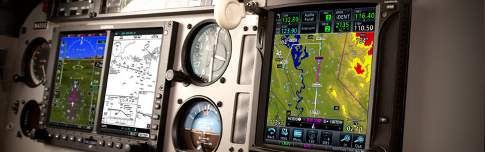
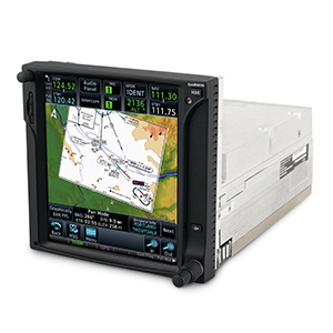
Packed full of powerful avionics, GTN 750 is a fully integrated GPS/NAV/COM/MFD solution ready and approved for installation in hundreds of makes and models of aircraft, including helicopters by the U.S.' FAA, Europe's EASA, Canada's TCCA and Brazil's ANAC authorities. The more than 6-inch tall system’s intuitive touchscreen controls and large display give you unprecedented access to high-resolution terrain mapping, graphical flight planning, geo-referenced charting, traffic display, multiple weather options, connectivity, advanced navigation and more.
Touch and Go
 With GTN 750’s revolutionary
touchscreen interface, you’re rarely more than 2 taps away from all of the system’s primary functions. Quickly pan across the map screen
simply by swiping your finger across the 6.9-inch diagonal high resolution TFT display. Or enter waypoint data with the full onscreen
keypad.
With GTN 750’s revolutionary
touchscreen interface, you’re rarely more than 2 taps away from all of the system’s primary functions. Quickly pan across the map screen
simply by swiping your finger across the 6.9-inch diagonal high resolution TFT display. Or enter waypoint data with the full onscreen
keypad.
There are multiple ways to reach information and lots of shortcuts built right in. The data displayed can easily be customized to instantly reach any page in the system right from the moving map or navigation pages. So it’s easy to fly with the information that’s most important to you while flying.
It’s even designed with raised grips in the bezel and a shelf across the lower edge of the display that serve as gripping points in both smoother and turbulent flight conditions. Traditional concentric knobs are also available for those who are used to that style of data input. If you have a GNS 430W/530W, your active flight plan automatically crossfills from the GTN to the GNS. You can also manually crossfill user waypoints back and forth between both devices.
Navigate with Ease
It’s easier than ever to help ensure everything is in check even before leaving the ground. The handy customizable checklist can be used to help ensure everything is ready to go from pre-flight to run-up to emergencies. It all begins with a simple and quick flight plan entry using FastFind which automatically begins searching for the nearest identifier just as soon as you start typing — so in most situations a press or two reveals just what you were thinking.
Graphical flight planning capabilities allow you to preview your entire route on the map screen and easily enter new waypoints or modify existing ones. The system even lets you load Victor and jet airways. A handy "rubber band" feature lets you grab any leg of your flight plan route and move it to accommodate a deviation or ATC amendment to your flight plan.
The GTN 750 also allows you to enter your most recently visited or nearest airports as waypoints and “Direct To” destinations. With high-resolution terrain mapping — including topography features, cities, airports, terminal areas, SUAs and more — and optional Class A or B TAWS alerting, you’ll safely find your way around the airspace with ease. Built-in Garmin FliteCharts® or optional Jeppesen®-style ChartView™, provides you with geo-referenced approach plates and procedures, while Garmin SafeTaxi® lets you see geo-referenced runways, taxiways, FBOs and hangars available in either the U.S., Europe or Canada.In IFR conditions, you now have more landing options, as well.
The SBAS/WAAS-certified, 15-channel GPS receiver generates five position updates per second, enabling you to fly GPS-guided LPV glidepath instrument approaches down to as low as 200 ft. The system also includes a complete package of VHF navigation capabilities, with a 200-channel VOR/ILS with localizer and glideslope. When you load procedures, the GTN will preload NAV frequencies for you to manually switch to and can auto select the VHF NAV source for ILS approaches. When a VOR is selected, it displays the radial and distance to the VOR. For quick access to a second approach attempt without interrupting the flight of the current approach, the GTN allows 2 approaches to be simultaneously loaded. Borrowing advanced navigation from Garmin's top-end flight decks provides the ability to create and execute custom holding patterns over an existing waypoint or user-defined waypoint. This same technology simplifies search and rescue operations with selection of 4 common search pattern types for easy entry into the flight plan including, Orbit Search, Parallel Line Search, Expanding Square and Sector Search pattern types. In addition, precise course deviation and roll steering outputs can be coupled to select autopilots so that IFR flight procedures may be flown automatically. This includes all ARINC 424 leg types, including NextGen radius-to-fix (RF) legs. And, when coupled with a G500/G600 flight display and compatible autopilot, the aircraft can fly fully coupled missed approaches, including heading legs as well as holds and search and rescue patterns.
Make Communication a Breeze
A fully certified, 2,280-channel VHF communications transceiver provides a standard 10 W (or optional 16 W) of power output. The system is pilot-selectable to both 25 kHz and 8.33 kHz channel spacing. With the GTN 750, you can set your standby Com frequency simply by touching the onscreen number pad — it even completes the leading '1' and trailing '0' to help save time. Another touch of the screen flip-flops your active and standby frequencies. Recent and favorite user frequencies also are a breeze to access. And you'll have added confidence knowing you're talking to the right controller every time with the automatic display of the station’s identifier right below the frequency, for example KIXD ASOS or CHICAGO ACC. For added safety, holding down the volume knob will automatically dial in the emergency frequency. The GTN also automatically decodes a station’s Morse code to provide a positive identification – no aural decoding required.
See More than Ever Before
With a wealth of multifunction display capabilities, the GTN 750 brings enhanced situational awareness to your cockpit. With high-resolution terrain mapping — including topography features, cities, airports, terminal areas, SUAs and more — and optional Class A or B TAWS alerting, you’ll safely find your way around sectional-like airspace depiction,with convenient altitude limits right on the moving map. When interfaced with a compatible fuel computer, a circle is depicted around the aircraft that indicates the estimated distance of travel to reach the aircraft’s fuel reserve and empty fuel conditions. Smart Airspace™ automatically highlights airspace close to your current altitude and de-emphasizes airspace away from the current altitude, which gives you increased situational awareness.
Add Traffic, Weather and More
The dual-link GDL® 88 allows the GTN 750 to display up to 60 ADS-B traffic targets. TargetTrend™ relative motion technology offers pilots a faster, more intuitive way to judge the direction and closure rate of intruding targets in relation to their aircraft’s position. TerminalTraffic™ provides pilots with the most comprehensive picture of ADS-B-equipped aircraft and ground vehicles in the airport environment. ADS-B-equipped aircraft in-flight are easily distinguished from ground vehicles and taxiing aircraft, which are displayed using distinct colors and symbols. All of this information is presented to the pilot on a simple, easy to understand SafeTaxi® diagram with reference to runways, taxiways hangar locations and more. Additionally, when configured for helicopter operations, TerminalTraffic helps pilots easily distinguish potential traffic conflicts while in the airport environment by minimizing nuisance alerts from fixed-wing aircraft and abbreviating select alerts while performing unique helicopter maneuvers such as hovering.
For helicopter use, Garmin's exclusive On Scene traffic mode helps pilots prevent continued traffic alerting when they’re aware of other traffic in the vicinity.The GDL 88 can also receive the FAA’s subscription-free FIS-B weather broadcasts that include graphical NEXRAD radar information, as well as NOTAMs, METARs, TAFs and more. Even better the GTN provides the GDL 88 with the WAAS position source required for ADS-B, so a WAAS version of the GDL 88 is not required. And consider adding a Garmin Traffic System to compliment the GDL 88 to provide the best possible traffic coverage.
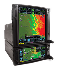
Couple the system with a GDL® 69 series datalink receiver and you can also receive SiriusXM weather and radio (subscriptions required). An optional GSR 56 can provide World Wide Weather data virtually anywhere on the globe, as well as the ability to make and receive phone calls and send and receive texts messages while in the air. To help pilots better understand weather trends, all of the NEXRAD or graphical datalink weather options are animated. You can also collect and display your own weather data with an onboard weather radar — such as the solid state and Doppler-capable GWX™ 70 with it’s optional turbulence detection and ground clutter suppression features, or a wide range of other third-party systems. And for easy access while viewing other items, the GWX 70 can be conveniently displayed and controlled right on the moving map page.
The GTN 750 can control the GMA 35 remote audio panel with 3D Audio, Telligence™ Voice Control, clearance recorder, advanced auto squelch and more, as well as the GTX™ 33 remote transponder. When installed together, this setup could save you up to 3-inch of panel space versus a typical GNS 430/530 install.
 Cockpit Connectivity
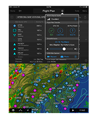
Let Garmin's Connext family of products keep your flight plans in sync and stream weather, traffic, GPS, and attitude information to select Connext-capable¹ apps and Garmin portables like Garmin Pilot™ by simply installing a Flight Stream 210. Use the flight plan already created and filed from Garmin Pilot to easily sync to your avionics upon hopping in the cockpit. And once airborne, it’s easier than ever to keep in sync with an ATC amendment — with only a button press or 2 a new route updated on either the GTN or Garmin Pilot without cumbersome re-entry. You’ll also be streaming all of the weather, traffic, GPS and attitude information that your avionics is already providing which makes it easy to cut down on the cockpit clutter of other portable wireless device(s).
Fly with Helicopter-specific Enhancements
 The GTN 750 is available with
a number of optional enhancements to help meet the unique demands of helicopter missions and it’s approved for installation in the most
popular makes and models of helicopters by the U.S.’ FAA, Europe’s EASA, Canada’s TCCA and Brazil’s ANAC authorities. It’s been designed
to meet the stringent helicopter vibration and temperature testing standards needed for environmental qualification. It also features a
helicopter-specific obstacle database that adds nearly 30,000 low-altitude obstacles, as well as a navigation database with heliports and
high-resolution terrain database.
The GTN 750 is available with
a number of optional enhancements to help meet the unique demands of helicopter missions and it’s approved for installation in the most
popular makes and models of helicopters by the U.S.’ FAA, Europe’s EASA, Canada’s TCCA and Brazil’s ANAC authorities. It’s been designed
to meet the stringent helicopter vibration and temperature testing standards needed for environmental qualification. It also features a
helicopter-specific obstacle database that adds nearly 30,000 low-altitude obstacles, as well as a navigation database with heliports and
high-resolution terrain database.
Remaining aware of where the wires are has never been easier than with Garmin WireAware™, wire-strike avoidance technology. WireAware graphically overlays the most comprehensive powerline information right on the moving map page for the U.S., as well as in some locations in both Canada and Mexico. In addition to its comprehensive coverage, using WireAware adds Hazardous Obstacle Transmission lines that span rivers and canyons and the like, which are particularly dangerous for aircraft. Nobody depicts powerline information quite like the GTN, each segment of the wire can be touched to instantly reveal both MSL and AGL – and they’re also included in the obstacle alerting so they’ll shade either yellow or red given your distance to the lines.
For the ultimate safety solution pair optional HTAWS alerting to provide 5-color shading and audible alerting to show nearby terrain, obstacles and wires in proximity to your helicopter as well as voice callouts when descending below 500 feet. And when you’re in the know of potential hazards, you can use Garmin's reduced protection and inhibit modes to help keep alerts to a minimum. When paired with a GRA 55, the GTN can be used to display the altitude and adds HTAWS alerting down to 50 feet. The GTN 750 is also optionally compatible with Night Vision Imaging Systems (NVIS) for use with a wide range of optics.
Stay Up-to-date
GTN 750 features a front-loading SD™ card reader, so you can easily update your databases. Keeping all of your GTNs databases in sync has never been easier — simply update 1 GTN and the other downloads the databases automatically, saving valuable time during the update process. Further, database preloading allows pilots to load the next release cycle in advance and activate upon the effective date, making it more convenient to fly with the latest information.
PilotPak™ database bundles are available on a single aircraft basis, saving you money and simplifying the update process — visit flyGarmin.com to learn more.


- Menu-driven graphical interface on color LCD touchscreen display
- Feature-rich MFD capabilities: moving map, chart display, airways, approaches and more
- GPS TSO’d to C146c, authorized for Class 1,2,3 (LPV)
- GPS WAAS-certified to Gamma-3 approach capability
- WAAS-corrected GPS signal accuracy to 1 M RMS
- Built-in GPS/ILS/VOR/LOC and glideslope capabilities available
- Graphical flight planning (including airway navigation)
- VHF COMM transceiver: 8.33 or 25 kHz channel spacing
- Com transmit power: 10 W standard, 16 W optional
- Extensive optional interface capabilities: lightning, weather, traffic, TAWS-B terrain alerting, and more
- Integrated control/display for remote transponder
- Integrated control for remote audio panel functions
- Flight control system interface for select autopilots
- Optional XM® WX satellite weather and XM Radio
- SafeTaxi® airport diagrams
- Award-winning Garmin product support and 2-year warranty
Physical & Performance: | |
| Unit dimensions, WxHxD: | 6.25"W x 6.00"H x 11.25"D (15.9 x 15.2 x 28.6 cm) |
| Display size, WxH: | 4.46"W x 5.27"H (11.33 x 13.39 cm); 6.9" diag (17.52 cm) |
| Display resolution, WxH: | 600 x 708 pixels |
| Display type: | Color TFT LCD; sunlight readable |
| Weight: | 9.3 lb (4.24 kg) |
| Voltage range: | 11-33 |
| Built-in VHF Comm: | yes |
| Transmit power: | 10 watts minimum; 16 watts minimum (optional) |
| Built-in VOR/Loc/Glideslope: | yes |
| SBAS/WAAS receiver: | 15 channel; TSO-C146c |
| IFR or VFR: | IFR |
Maps, Databases & Memory: | |
| Basemap: | yes |
| Navigation data: | full and non-precision approaches, DPs and STARs, Victor/Jet Airways, eCharts (w/ Optional Enablement) |
| Navigation database coverage areas: | Americas, International or Worldwide |
| Preloaded Terrain database: | yes |
| Preloaded Obstacle database: | yes |
| Preloaded SafeTaxi™ airport diagrams: | yes |
| Preloaded Garmin FliteCharts®: | yes (U.S. only) |
| Jeppesen ChartView™: | optional |
| Waypoints/favorites/locations: | 1000 |
| Flight plans: | 99 reversible; up to 100 waypoints each |
Features & Benefits: | |
| Fly SBAS/WAAS approaches: | yes |
| Front-loading datacards (conveniently update database information): | yes |
| XM WX Weather & Radio for U.S. & Canada compatible: | yes |
| Traffic Information Services (TIS) alerts compatible: | yes |
| Class B TAWS alerting compatible: | yes |
| Additional: | 2 year warranty Eligible for PilotPak databases *Databases included: world-wide basemap, world-wide obstacles, world-wide terrain, region-specific NavData, US SafeTaxi, US Airport Directory |
- GTN 750
- Cleaning cloth
- SD card with databases
- GA-35 antenna
- Installation kit
- Simulation software DVD
- Familiarization video DVD
- Pilot's guide
- Cockpit reference guide
- Complimentary database update certificate


